


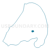
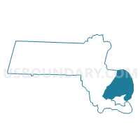
Dennis Precinct 5, Barnstable County, Massachusetts
About
Outline

Summary
| Unique Area Identifier | 593608 |
| Name | Dennis Precinct 5 |
| County | Barnstable County |
| State | Massachusetts |
| Area (square miles) | 3.46 |
| Land Area (square miles) | 3.25 |
| Water Area (square miles) | 0.21 |
| % of Land Area | 94.02 |
| % of Water Area | 5.98 |
| Latitude of the Internal Point | 41.70852590 |
| Longtitude of the Internal Point | -70.15658200 |
Maps

Graphs
Select a template below for downloading or customizing gragh for Dennis Precinct 5, Barnstable County, Massachusetts


Neighbors
Neighoring Voting District (by Name) Neighboring Voting District on the Map
- Brewster Precinct 1, Barnstable County, MA
- Dennis Precinct 1, Barnstable County, MA
- Dennis Precinct 2, Barnstable County, MA
- Dennis Precinct 4, Barnstable County, MA
- Harwich Precinct 4, Barnstable County, MA
- Yarmouth Precinct 2, Barnstable County, MA
- Yarmouth Precinct 7, Barnstable County, MA
Top 10 Neighboring County Subdivision (by Population) Neighboring County Subdivision on the Map
- Yarmouth town, Barnstable County, MA (23,793)
- Dennis town, Barnstable County, MA (14,207)
- Harwich town, Barnstable County, MA (12,243)
- Brewster town, Barnstable County, MA (9,820)
Top 10 Neighboring Place (by Population) Neighboring Place on the Map
- South Yarmouth CDP, MA (11,092)
- Yarmouth Port CDP, MA (5,320)
- Northwest Harwich CDP, MA (3,929)
- South Dennis CDP, MA (3,643)
- East Dennis CDP, MA (2,753)
- Dennis CDP, MA (2,407)
Top 10 Neighboring Elementary School District (by Population) Neighboring Elementary School District on the Map
Top 10 Neighboring Secondary School District (by Population) Neighboring Secondary School District on the Map
Top 10 Neighboring Unified School District (by Population) Neighboring Unified School District on the Map
Top 10 Neighboring State Legislative District Lower Chamber (by Population) Neighboring State Legislative District Lower Chamber on the Map
Top 10 Neighboring State Legislative District Upper Chamber (by Population) Neighboring State Legislative District Upper Chamber on the Map
Top 10 Neighboring 111th Congressional District (by Population) Neighboring 111th Congressional District on the Map
Top 10 Neighboring Census Tract (by Population) Neighboring Census Tract on the Map
- Census Tract 120.01, Barnstable County, MA (5,732)
- Census Tract 108, Barnstable County, MA (4,878)
- Census Tract 118.02, Barnstable County, MA (4,255)
- Census Tract 110.02, Barnstable County, MA (4,157)
- Census Tract 115, Barnstable County, MA (4,029)
- Census Tract 114, Barnstable County, MA (2,991)
- Census Tract 113, Barnstable County, MA (2,600)
Top 10 Neighboring 5-Digit ZIP Code Tabulation Area (by Population) Neighboring 5-Digit ZIP Code Tabulation Area on the Map
- 02631, MA (9,679)
- 02645, MA (9,663)
- 02664, MA (9,371)
- 02675, MA (6,577)
- 02660, MA (6,261)
- 02638, MA (3,207)